SPQU AD 2.1 AERODROME LOCATION INDICATOR AND NAME
|
|
SPQU - AREQUIPA / INTL ALFREDO RODRIGUEZ BALLÓN
|
|
SPQU AD 2.2 AERODROME GEOGRAPHICAL AND ADMINISTRATIVE DATA
|
|
1
|
To be translated
|
162026S 0713415W
1265 m FM THR 28 DESPLAZADO
1265 m FM THR 28 DISPLACED
|
|
|
ARP coordinates and site at AD
|
2
|
To be translated
|
8 km al NW
8 km to the NW
|
|
|
Direction and distance from (city)
|
3
|
To be translated
|
Elev: 8400 FT (2560 M) / T: 22.6° C (Mean Low T: NIL)
|
|
|
Elevation / Reference temperature (Mean Low temperature)
|
4
|
To be translated
|
NIL
|
|
|
Geoid undulation at AD ELEV PSN
|
5
|
To be translated
|
6° W (2020) / 0°13' W
|
|
|
MAG VAR / Annual change
|
6
|
To be translated
|
AEROPUERTOS ANDINOS DEL PERÙ S.A. - AAP
Av. Aviación S/N Zamácola, Distrito de Cerro Colorado - Arequipa
Arequipa PERÚ
Tel: (054) 344834
AFS: SPQUYDYX
email: atencionalcliente@aap.com.pe
|
|
|
AD Administration, address, telephone, telefax, telex, AFS
|
7
|
To be translated
|
IFR/VFR
|
|
|
Types of traffic permitted (IFR/VFR)
|
8
|
To be translated
|
NIL
|
|
|
Remarks
|
|
SPQU AD 2.3 OPERATIONAL HOURS
|
|
1
|
To be translated
|
1100-0300 (UTC +5)
|
|
|
AD Administration
|
2
|
To be translated
|
1100-0300 (UTC +5)
|
|
|
Customs and immigration
|
3
|
To be translated
|
1100-0300 (UTC +5)
|
|
|
Health and sanitation
|
4
|
To be translated
|
1100-0300 (UTC +5)
|
|
|
AIS Briefing Office
|
5
|
To be translated
|
1100-0300 (UTC +5)
|
|
|
ATS Reporting Office (ARO)
|
6
|
To be translated
|
H24
|
|
|
MET Briefing Office
|
7
|
To be translated
|
1100-0300 (UTC +5)
|
|
|
ATS
|
8
|
To be translated
|
1130-0230 (UTC +5)
y O/R
1130-0230 (UTC +5)
|
|
|
Fuelling
|
9
|
To be translated
|
1100-0300 (UTC +5)
|
|
|
Handling
|
10
|
To be translated
|
H24
|
|
|
Security
|
11
|
To be translated
|
NIL
|
|
|
De-icing
|
12
|
To be translated
|
COM H24
|
|
|
Remarks
|
|
SPQU AD 2.4 HANDLING SERVICES AND FACILITIES
|
|
1
|
To be translated
|
01 Montacarga de 25 t de capacidad. 01 carreta. No se dispone de personal para manipuleo de carga.
01 Forklift of 25 t capacity. 01 CARTS. No personnel available for cargo handling.
|
|
|
Cargo-handling facilities
|
2
|
To be translated
|
To be translated: JET A1
To be translated: TURBO
Fuel: JET A1
Oil: TURBO
|
|
|
Fuel / oil types
|
3
|
To be translated
|
En plataforma. Sin restricción.
On apron. Without restriction.
|
|
|
Fuelling facilities/capacity
|
4
|
To be translated
|
NIL
|
|
|
De-icing facilities
|
5
|
To be translated
|
NIL
|
|
|
Hangar space for visiting aircraft
|
6
|
To be translated
|
Sí
Yes
|
|
|
Repair facilities for visiting aircraft
|
7
|
To be translated
|
NIL
|
|
|
Remarks
|
|
SPQU AD 2.5 PASSENGER FACILITIES
|
|
1
|
To be translated
|
En la ciudad
In the city
|
|
|
Hotels
|
2
|
To be translated
|
En el AD y la ciudad
In the AD and in the city
|
|
|
Restaurants
|
3
|
To be translated
|
Taxis desde y hacia la ciudad
Taxis from and to the city
|
|
|
Transportation
|
4
|
To be translated
|
En el aeropuerto y en la ciudad
In the airport and in the city
|
|
|
Medical facilities
|
5
|
To be translated
|
To be translated: En el AD y la ciudad
To be translated: NIL
Bank: In the AD and in the city
Post: NIL
|
|
|
Bank and Post Office
|
6
|
To be translated
|
En el AD y la ciudad
In the AD and in the city
|
|
|
Tourist Office
|
7
|
To be translated
|
NIL
|
|
|
Remarks
|
|
SPQU AD 2.6 RESCUE AND FIRE FIGHTING SERVICES
|
|
1
|
To be translated
|
CAT A7
|
|
|
AD category for fire fighting
|
2
|
To be translated
|
Equipo de primeros auxilios, Equipos de mercancÍas peligrosas y 02 vehÍculos
First aid equipment, Dangerous goods equipment and 02 vehicles
|
|
|
Rescue equipment
|
3
|
To be translated
|
Hasta 77 t (Empresa externa)
Up to 77 t (External company)
|
|
|
Capability for removal of disabled aircraft
|
4
|
To be translated
|
942174403/054-344834
seg.aqp@aap.com.pe
|
|
|
Remarks
|
|
SPQU AD 2.7 SEASONAL AVAILABILITY
|
|
1
|
To be translated
|
NIL
|
|
|
Types of clearing equipment
|
2
|
To be translated
|
NIL
|
|
|
Clearance priorities
|
3
|
To be translated
|
NIL
|
|
|
Use of material for movement area surface treatment
|
4
|
To be translated
|
NIL
|
|
|
Specially prepared winter runways
|
5
|
To be translated
|
NIL
|
|
|
Remarks
|
|
SPQU AD 2.8 APRONS, TAXIWAYS AND CHECK LOCATIONS DATA
|
|
1
|
To be translated
|
APN
|
Calcestruzzo ed asfalto
Concrete and asphalt
|
PCN 43/R/B/X/T
PCN 39/F/B/X/T
|
|
|
|
Apron surface and strength
|
2
|
To be translated
|
ALFA
|
23 M
|
Asfalto
Asphalt
|
PCN 39/F/B/X/T
|
TXL BRAVO
|
23 M
|
Asfalto
Asphalt
|
PCN 39/F/B/X/T
|
TXL BRAVO 1
|
23 M
|
Asfalto
Asphalt
|
PCN 39/F/B/X/T
|
|
|
|
Taxiway width, surface and strength
|
3
|
To be translated
|
NIL
|
|
|
Altimeter checkpoint location and elevation
|
4
|
To be translated
|
NIL
|
|
|
VOR checkpoints
|
5
|
To be translated
|
NIL
|
|
|
INS checkpoints
|
6
|
To be translated
|
VOR/DME sin letrero, NO APLICABLE, situado fuera de las inmediaciones del aeropuerto con diferentes niveles de altitud.
TWY ALFA cerrada.
VOR/DME Without sign, NOT APPLICABLE, placed outside the vicinity of the airport at different altitude levels.
TWY ALFA closed.
|
|
|
Remarks
|
|
SPQU AD 2.9 SURFACE MOVEMENT GUIDANCE AND CONTROL SYSTEM AND MARKINGS
|
|
1
|
To be translated
|
Señales de guía de rodaje en todas las intersecciones entre TWY y RWY y en todos los puntos de espera. Líneas de guía en la plataforma. Guía visual de estacionamiento en los puestos de aeronaves.
Taxiing guidance signs at all intersections between TWY and RWY, and at all holding positions. Guidance lines on apron. Visual parking guidance at aircraft stands.
|
|
|
Use of aircraft stand ID signs, TWY guide lines and visual docking/parking guidance system of aircraft stands
|
2
|
To be translated
|
RWY: Designación, THR, TDZ, eje y borde de pista, según corresponda, señalados. Bordes, THR y extremo iluminados.
TWY: Puntos de espera en todas las intersecciones TWY/RWY, señalados. Bordes iluminados.
RWY: Designation, THR, TDZ, Runway centre line and Runway edge, as applicable, marked. Lighted Edges, THR and Runway end.
TWY: Holding positions at all intersections between TWY/RWY, marked. Lighted Runway edges.
|
|
|
RWY and TWY markings and LGT
|
3
|
To be translated
|
NIL
|
|
|
Stop bars and runway guard lights
|
4
|
To be translated
|
NIL
|
|
|
Other runway protection measures
|
5
|
To be translated
|
NIL
|
|
|
Remarks
|
|
SPQU AD 2.10 AERODROME OBSTACLES
|
|
To be translated / In Area 2
|
To be translated
|
To be translated
|
To be translated
|
To be translated
|
To be translated
|
To be translated
|
OBST ID / Designation
|
OBST type
|
OBST position
|
ELEV/HGT
|
Markings/
Type,
colour
|
Remarks
|
a
|
b
|
c
|
d
|
e
|
f
|
|
To be translated / In Area 3
|
To be translated
|
To be translated
|
To be translated
|
To be translated
|
To be translated
|
To be translated
|
OBST ID / Designation
|
OBST type
|
OBST position
|
ELEV/HGT
|
Markings/
Type,
colour
|
Remarks
|
a
|
b
|
c
|
d
|
e
|
f
|
|
SPQU AD 2.11 METEOROLOGICAL INFORMATION PROVIDED
|
|
1
|
To be translated
|
OMA
|
|
|
Associated MET Office
|
2
|
To be translated
|
1100 - 2300 (UTC + 5)
|
|
|
Hours of service
MET Office outside hours
|
3
|
To be translated
|
OMA/SPQU-SPJC
24 horas
24 hours
|
|
|
Office responsible for TAF preparation
Period of validity
|
4
|
To be translated
|
TREND (TR) Cada hora
TREND (TR) Every hour
|
|
|
Trend forecast
Interval of issuance
|
5
|
To be translated
|
Consultazione personale (P) Sí
Personal consultation (P) Yes
|
|
|
Briefing/consultation provided
|
6
|
To be translated
|
Mapas, Pronóstico, Observaciones e informes MET (Productos WAFS). ES
Maps, Forecast, Observations and MET Reports (WAFS Products).
|
|
|
Flight documentation
Language(s) used
|
7
|
To be translated
|
Mapas, Cartas, Imágenes MET de satelite e información MET Codificada.
Maps, Charts, MET Satellite Imagery and MET Encoded information.
|
|
|
Charts and other information available for briefing or consultation
|
8
|
To be translated
|
Terminal AMHS CADAS, Banco de Datos alterno OPMET, Internet.
AMHS CADAS Terminal, OPMET Alternate Data Bank, Internet.
|
|
|
Supplementary equipment available for providing information
|
9
|
To be translated
|
TWR SPQU
ARO SPQU
APP SPQU
|
|
|
ATS units provided with information
|
10
|
To be translated
|
NIL
|
|
|
Additional information (limitation of service, etc.)
|
|
SPQU AD 2.12 RUNWAY PHYSICAL CHARACTERISTICS
|
|
To be translated
|
To be translated
|
To be translated
|
To be translated
|
To be translated
|
To be translated
|
RWY Designator
|
TRUE BRG
|
Dimension of RWY (M)
|
Strength (PCN) and surface of RWY and SWY
|
THR coordinates
RWY end coordinates
THR geoid undulation
|
THR elevation and highest elevation of TDZ of precision APP RWY
|
1
|
2
|
3
|
4
|
5
|
6
|
10
|
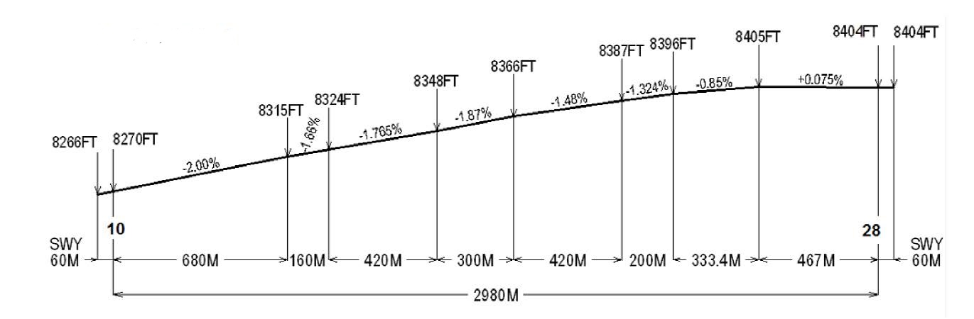
093.00°
|
2980 x 45
|
PCN 39/F/B/X/T
Asfalto
Asphalt
SWY: NIL
|
162023.42S
0713504.99W
END: NIL
GUND: NIL
|
THR 8270.0 FT
TDZ: NIL
|
28
|
273.00°
|
2980 x 45
|
PCN 39/F/B/X/T
Asfalto
Asphalt
SWY: NIL
|
162028.74S
0713324.79W
END: NIL
GUND: NIL
|
THR 8400 FT
TDZ: NIL
|
|
To be translated
|
To be translated
|
To be translated
|
To be translated
|
To be translated
|
To be translated
|
To be translated
|
To be translated
|
RWY Designator
|
Slope of RWY-SWY
|
SWY dimensions (M)
|
CWY dimensions (M)
|
Strip dimensions (M)
|
RESA dimensions (M)
|
Location/
description of arresting system
|
OFZ
|
1
|
7
|
8
|
9
|
10
|
11
|
12
|
13
|
10
|
NIL
|
60 x 45
|
NIL
|
3100 x 150
|
NIL
|
NIL
|
NIL
|
28
|
NIL
|
60 x 45
|
NIL
|
3100 x 150
|
NIL
|
NIL
|
NIL
|
|
To be translated
|
To be translated
|
RWY Designator
|
Remarks
|
1
|
14
|
10
|
NIL
|
28
|
DTHR 28 = 450 m / S16 20 27.95 W 071 33 39.86
|
|
|
|
SPQU AD 2.13 DECLARED DISTANCES
|
|
To be translated
|
TORA
(M)
|
TODA
(M)
|
ASDA
(M)
|
LDA
(M)
|
To be translated
|
RWY Designator
|
Remarks
|
1
|
2
|
3
|
4
|
5
|
6
|
10
|
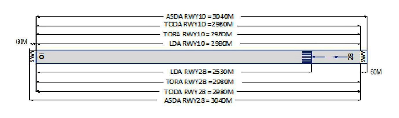
2980
|
2980
|
3040
|
2980
|
NIL
|
28
|
2980
|
2980
|
3040
|
2530
|
DTHR 450 m
|
|
|
|
SPQU AD 2.14 APPROACH AND RUNWAY LIGHTING
|
|
To be translated
|
To be translated
|
To be translated
|
To be translated
|
To be translated
|
To be translated
|
RWY Designator
|
APCH LGT type LEN INTST
|
THR LGT colour WBAR
|
VASIS (MEHT) PAPI
|
TDZ, LGT LEN
|
RWY Centre Line LGT Length, spacing, colour, INTST
|
1
|
2
|
3
|
4
|
5
|
6
|
10
|
OTHER
CAT1
480 M
PALS
|
Verde
Green
|
PAPI
3°
38.63 FT
|
NIL
|
NIL
|
28
|
NIL
|
Verde
Green
|
PAPI
3°
60.01 FT
|
NIL
|
NIL
|
|
To be translated
|
To be translated
|
To be translated
|
To be translated
|
To be translated
|
RWY Designator
|
RWY edge LGT LEN, spacing colour INTST
|
RWY End LGT colour WBAR
|
SWY LGT LEN
colour
|
Remarks
|
1
|
7
|
8
|
9
|
10
|
10
|
2950 M, 60 M
Bianco
White
|
Rosso
Red
|
NIL
|
Luces de destello
Flashing lights
|
28
|
2950 M, 60 M
Bianco
White
|
Rosso
Red
|
NIL
|
LGT THR Desplazado 450 m
PAPI restricción de uso desde 2.5NM THR
Displaced THR LGT 450 m
PAPI use restriction from 2.5 NM THR
|
|
SPQU AD 2.15 OTHER LIGHTING, SECONDARY POWER SUPPLY
|
|
1
|
To be translated
|
ABN: Edificio TWR FLG W/G EV 2.5 SEC, HN e IMC
ABN: Building TWR FLG W/G EV 2.5 SEC, HN and IMC
|
|
|
ABN/IBN location, characteristics and hours of operation
|
2
|
To be translated
|
182 m del THR 10 LGTD
182 m fromTHR 10 LGTD
|
|
|
LDI location and LGT Anemometer location and LGT
|
3
|
To be translated
|
To be translated/Taxiway edge:
ALFA
|
|
|
TWY edge and centre line lighting
|
4
|
To be translated
|
SÍ 10 s
Yes 10 s
|
|
|
Secondary power supply/switch-over time
|
5
|
To be translated
|
NIL
|
|
|
Remarks
|
|
SPQU AD 2.16 HELICOPTER LANDING AREA
|
|
1
|
To be translated
|
NIL
|
|
|
Coordinates TLOF or THR of FATO
Geoid undulation
|
2
|
To be translated
|
NIL
|
|
|
TLOF and/or FATO elevation M/FT
|
3
|
To be translated
|
NIL
|
|
|
TLOF and FATO area dimensions, surface, strength, marking
|
4
|
To be translated
|
NIL
|
|
|
True BRG of FATO
|
5
|
To be translated
|
NIL
|
|
|
Declared distance available
|
6
|
To be translated
|
NIL
|
|
|
APP and FATO lighting
|
7
|
To be translated
|
NIL
|
|
|
Remarks
|
|
SPQU AD 2.17 ATS AIRSPACE
|
|
To be translated
|
To be translated
|
To be translated
|
To be translated
|
To be translated
|
To be translated
|
To be translated
|
Designation and lateral limits
|
Vertical limits
|
Airspace classification
|
ATS unit call sign Language(s)
|
Transition altitude
|
Hours of applicability
|
Remarks
|
1
|
2
|
3
|
4
|
5
|
6
|
7
|
AREQUIPA TMA
Desde 163200S 0725800W por un arco de sentido horario de 50 NM de radio con centro no ponto de coordenadas 162216S 0720801W (VOR UAS) - 160122S 0725601W - 155237S 0723226W - 154053S 0715937W - 153311S 0713808W por un arco de sentido horario de 47 NM de radio con centro no ponto de coordenadas 162021S 0713550W (VOR EQU) - 170418S 0711804W - 163200S 0714100W - 165000S 0722800W para o ponto de origem.
Area bounded by lines joining points 163200S 0725800W then along the clockwise arc of a circle of 50 NM radius centred on 162216S 0720801W (VOR UAS) to 160122S 0725601W - 155237S 0723226W - 154053S 0715937W - 153311S 0713808W then along the clockwise arc of a circle of 47 NM radius centred on 162021S 0713550W (VOR EQU) to 170418S 0711804W - 163200S 0714100W - 165000S 0722800W to point of origin.
|
|
NIL
|
AREQUIPA TORRE
Inglese, Spagnolo
English, Spanish
|
18500 FT AMSL
|
NIL
|
Espacio Aéreo A/D
|
ATZ SPQU
Circulo con centro en 162026S 0713415W con radio de 3 NM.
Circular area centered on 162026S 0713415W within a 3 NM radius.
|
|
D
|
AREQUIPA TORRE
Inglese, Spagnolo
English, Spanish
|
18500 FT AMSL
|
NIL
|
NIL
|
CTR SPQU
Circulo con centro en 162021S 0713550W (VOR EQU) con radio de 5.8 NM.
Circular area centered on 162021S 0713550W (VOR EQU) within a 5.8 NM radius.
|
|
D
|
AREQUIPA TORRE
Inglese, Spagnolo
English, Spanish
|
18500 FT AMSL
|
NIL
|
Espacio aéreo semicircular, hacia el sur, con un radio de 5.8 NM con centro en el VOR/DME EQU (16°20’21.05”S-071°35’49.76”W) y unida con una línea (ubicada 1 NM al norte del eje de la pista 10/28 y su prolongación) en los puntos 16°19’01.89”S - 071°41’42.01”W y 16°19’39.77”S - 071°29’50.59”W.
|
|
SPQU AD 2.18 ATS COMMUNICATION FACILITIES
|
|
To be translated
|
To be translated
|
To be translated
|
To be translated
|
To be translated
|
To be translated
|
To be translated
|
Service
designation
|
Callsign
|
Frequency
|
SATVOICE
|
Logon address
|
Hours of operation
|
Remarks
|
1
|
2
|
3
|
4
|
5
|
6
|
7
|
ATIS SPQU
|
AEROPUERTO AREQUIPA
|
130.900 MHZ
|
NIL
|
NIL
|
H24
|
NIL
|
EMERGENCIA
|
EMERGENCIA
|
121.500 MHZ
|
NIL
|
NIL
|
H24
|
NIL
|
SMC SPQU
|
AREQUIPA SUPERFICIE
|
121.900 MHZ
|
NIL
|
NIL
|
H24
|
NIL
|
TWR
|
AREQUIPA TORRE
|
118.700 MHZ
|
NIL
|
NIL
|
H24
|
ALTERNA 118.2 MHz
|
|
SPQU AD 2.19 RADIO NAVIGATION AND LANDING AIDS
|
|
To be translated
|
To be translated
|
To be translated
|
To be translated
|
To be translated
|
To be translated
|
To be translated
|
To be translated
|
Type of aid
MAG VAR
CAT of ILS/MLS
DECL
|
ID
|
Frequency
|
Hours of operation
|
Site of transmitting antenna coordinates
|
Elevation of DME transmitting antenna
|
Service
volume
radius
from GBAS
reference
Point
|
Remarks
|
1
|
2
|
3
|
4
|
5
|
6
|
7
|
8
|
LOC 10
(06° W)
ILS CAT I
|
IARB
|
109.700 MHZ
|
H24
|
162029.2S
0713316.3W
|
NIL
|
NIL
|
NIL
|
GP 10
(06° W)
ILS
|
IARB
|
333.200 MHZ
|
H24
|
162027.4S
0713457.4W
|
NIL
|
NIL
|
NIL
|
DME 10
(06° W)
ILS CAT I
|
IARB
|
CH 34X
|
H24
|
162027.4S
0713457.4W
|
NIL
|
NIL
|
NIL
|
VOR
(05° W)
|
UAS
|
113.500 MHZ
|
H24
|
162216.3S
0720801.1W
|
NIL
|
NIL
|
VAR 5° W 2020
|
VOR/DME
(06° W)
|
EQU
|
113.700 MHZ
CH 84X
|
H24
|
162021.1S
0713549.8W
|
39 FT
|
NIL
|
NIL
|
|
SPQU AD 2.20 LOCAL AERODROME REGULATIONS
|
|
|
|
Several local regulations apply at Arequipa Airport. The regulations are compiled in a manual that can be consulted at the Airport Headquarters Office. Among other matters, this manual contains:
-
the meaning of markings and signs;
-
information about aircraft stands, including visual docking guidance system;
-
information about taxiing from aircraft stands, including taxiing clearance;
-
limitations for large aircraft operations, including limitations on the use of its own energy for taxiing;
-
the helicopter operations;
-
the assistance of marshalls and for towing;
-
the use of engine power higher than the idle power;
-
the engine starting and the APU use;
-
the fuel spillage; and
-
the precautions during extreme weather conditions.
Assistance of marshalls and more information about regulations can be obtained from the TWR or from the Surface Movement Control (SMC). Information will be provided to each aircraft when a local regulation is important for the safe operation of aircraft over the apron, TWR or SMC. Local regulations can be obtained by requesting them in writing from:
Aeropuertos Andinos del Perú S.A. Av. Aviación S/N Zamácola - Cerro Colorado Arequipa - PERÚ
|
2 Taxiing to and from Aircraft stands
|
2.1 AAP S.A. will assign through the TWR an aircraft stand number to the arriving aircraft.
2.2 Departing flights must contact TWR for ATC clearance prior to starting the taxiing. Departing aircraft shall be granted clearance to start engines, push-back, and taxiing instructions from the apron at the frequency 118.7 MHz.
|
3 Parking area for small aircraft (General Aviation )
|
3.1 General aviation aircraft will be guided by marshalls to the parking area for small aircraft.
|
4 Helicopter Parking area
|
4.1 There is no exclusive helicopter parking area
|
5 Apron - Taxiing in winter conditions
|
|
|
|
|
|
|
7 School and Training Flights - Technical Test Flights - Use of runways
|
7.1 Training and technical test flights will be carried out with the authorization of DGAC.
|
8 Helicopter Traffic - Limitations
|
No limitations, follow ATS instructions.
|
9 Removal of disabled Aircraft from Runways
|
In case of an aircraft is rendered disabled on a runway, it is the duty of the owner or user of that aircraft to ensure that it is removed as soon as possible. If the owner does not remove a disabled aircraft from the runway as soon as possible, it shall be removed by the aerodrome authorities at the owner’s or user’s expense.
|
|
|
IFR take-off minima are regulated by RAP 91.370.
Operators must comply with RAP 91.600 for alternate aerodromes.
|
SPQU AD 2.21 NOISE ABATEMENT PROCEDURES
|
|
1 Noise abatement procedures
|
|
|
SPQU AD 2.22 FLIGHT PROCEDURES
|
|
1 Procedures for IFR flights within TMA
|
Instrument flight procedures (SID, STAR, Approach, Holding, etc.) must not be modified. The outbound and inbound headings,
minimum of descent
, etc., have been calculated considering the surrounding topography, therefore, any variation in them could reduce the margin of protection against obstacles of the corresponding segment, dangerously bringing the aircraft closer to the obstacles.
Due to the proximity of the elevated terrain to the north and east of the aerodrome, flights to the north of the aerodrome are forbidden, moreover, for the same reasons, night operation is not permitted.
|
|
|
In the event of communications failure, the pilot shall act in accordance with the procedures for communications failure set out in ICAO Annex 2.
|
3 Procedures for VFR flights within TMA
|
Whenever traffic conditions permit, ATC clearance will be given for VFR flights under the conditions described below:
-
A flight plan for requesting ATC clearance, containing items 7 to 18 and indicating the purpose of the flight, shall be submitted.
-
It is only possible to release from the ATC clearance when prior permission has been obtained.
-
The flight shall be conducted with a vertical visual reference to the ground.
-
Two-way radio communication will be established at the frequency 118.7 MHz.
|
4 Procedures for VFR flights within CTR
|
-
A flight plan will be filled out for the corresponding flight.
-
The ATC clearance will be obtained from the Control Tower.
-
It is only possible to release from the ATC clearance when prior permission has been obtained.
-
The flight shall be conducted with a vertical visual reference to the ground.
Two-way radio communication will be established at the frequency 118.7 MHz before the flight enters the control area.
|
SPQU AD 2.23 ADDITIONAL INFORMATION
|
|
1 Local flightRestrictions
|
Non-scheduled, civilian or military flights operators must coordinate flight plans 24 hours before the estimated time of departure (ETD) with the AAP aerodrome administrator via e-mail to: aqpcoordinacionesfpl@aap.com.pe
|
SPQU AD 2.24 CHARTS RELATED TO AN AERODROME
|
|
|
CARTAS /
CHARTS
|
NOMBRE /
NAME
|
PÁGINA /
PAGES
|
|
1 Plano de Aeródromo - OACI
|
|
AD 2 SPQU 13 |
|
2 Carta de Área - OACI (rutas de salidas y llegadas)
|
|
AD 2 SPQU 15 |
|
3 Descripción de Carta de Área - OACI (rutas de salidas y llegadas)
|
|
AD 2 SPQU 15-1 |
|
4 Carta de Salida Normalizada - Vuelo por Instrumentos (SID) - OACI
|
RWY 28 KOLKA 3F |
AD 2 SPQU 17 |
|
RWY 28 GAVAR 2F
|
AD 2 SPQU 17A |
|
RWY 28 TONOS 3F
|
AD 2 SPQU 17B |
|
RWY 28 SIMEL 1F - KOLKA 3G
|
AD 2 SPQU 17C |
|
RWY 28 SIMEL 1G
|
AD 2 SPQU 17D |
|
5 Carta de Llegada Normalizada - Vuelo por Instrumentos (STAR) - OACI
|
RWY 10 TOROK 1 - KOLKA 3A - ASUPA1A |
AD 2 SPQU 19 |
|
RWY 10 TONOS 3A - GAVAR 2A
|
AD 2 SPQU 19A |
|
RWY 10 RNAV ASUPA 1B
|
AD 2 SPQU 19B |
|
6 Carta de Aproximación por Instrumentos (IAC) - OACI
|
ILS RWY 10 |
AD 2 SPQU 21 |
|
VOR RWY 10
|
AD 2 SPQU 21A |
|
7 Carta de Aproximación Visual - OACI
|
|
AD 2 SPQU 23 |
|
SPQU AD 2.25 VISUAL SEGMENT SURFACE (VSS) PENETRATION
|
|
|
|